If you work in geospatial technology, environmental science, or infrastructure, you know that the quality of your foundational data dictates the quality of your results. For decades, the United States has relied on a map of its rivers, streams, and lakes that was, for its time, a monumental achievement. But that time has passed. The legacy National Hydrography Dataset (NHD), born from paper maps of a bygone era, has been pushed to its limits. It’s inaccurate, outdated, and fundamentally disconnected from the high-resolution 3D reality of the terrain we can now measure with incredible precision.
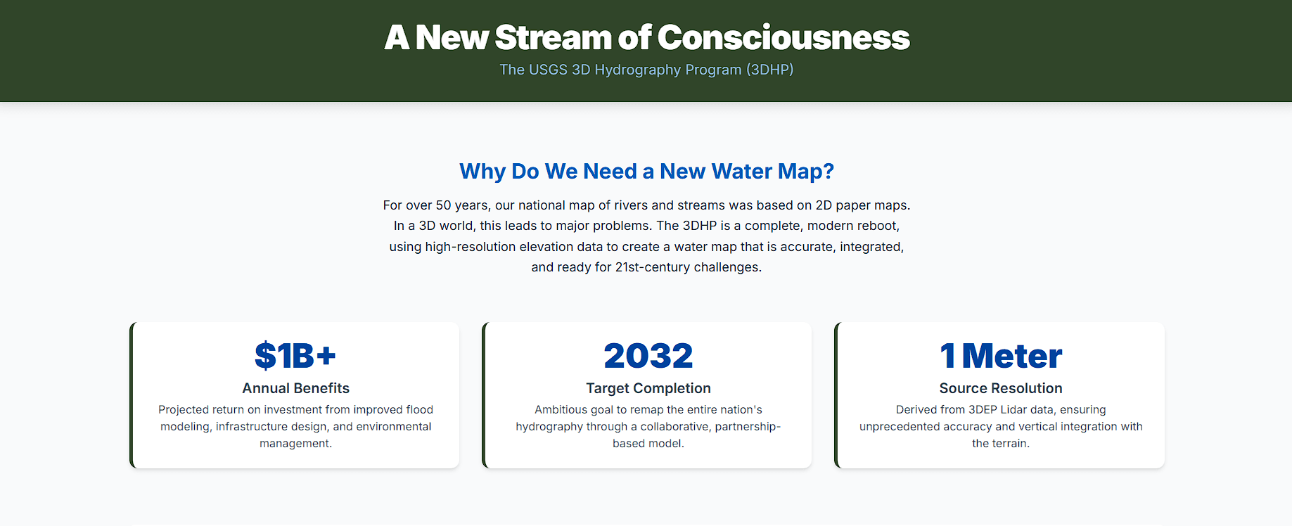
This isn't just a technical problem; it's a scientific and economic one. When your data shows a river flowing uphill or on the side of a valley, it breaks the models essential for everything from flood prediction to infrastructure design. To solve this, the U.S. Geological Survey (USGS) has embarked on its most ambitious modernization of water data in over 50 years: the 3D Hydrography Program (3DHP). This isn't just an update. It's a complete paradigm shift, projected to deliver over $1 billion in annual benefits by creating a new digital-first, three-dimensional map of America's water.
Let's dive into what the 3DHP is, why it's so critical, and how it will reshape our understanding of the nation's most vital resource.
The Problem: When Good Data Goes Bad
To understand why the 3DHP is a game-changer, you first have to understand the tools it's replacing: the National Hydrography Dataset (NHD), the Watershed Boundary Dataset (WBD), and their successor, the NHDPlus High Resolution (NHDPlus HR). For over two decades, this trio was the gold standard for digital hydrography. The NHD mapped the stream network, the WBD defined the watersheds, and the NHDPlus HR enriched it all with analytical attributes.
But their foundation was built on sand—or, more accurately, on paper. Much of the original NHD was painstakingly digitized from 1:24,000-scale topographic maps created between the 1940s and 1990s. The result?
- Positional Inaccuracy: Streams could be horizontally misplaced by many meters. More critically, they were 2D lines with no inherent vertical information. When draped over a modern Digital Elevation Model (DEM) from the 3D Elevation Program (3DEP), these legacy streams often appear to defy gravity, sitting on hillsides instead of in valleys.
- Outdated Content: The American landscape is not static. Rivers change course, new canals are dug, and dams are built. The NHD, a patchwork of data from different eras, often failed to reflect these realities.
- Scientific Compromise: The misalignment between elevation and hydrography forced modelers into a scientifically unsound workaround known as "stream burning." They would artificially carve the NHD's path into the DEM to force water to flow where the map said it should, corrupting the authoritative elevation data in the process.
These limitations weren't just academic annoyances. They had real-world consequences, hindering our ability to accurately predict flood inundation, design resilient infrastructure like bridges and culverts, and manage water quality. The demand for better data, documented in the National Hydrography Requirements and Benefits Study (HRBS), was overwhelming. The nation needed to reboot its water map.
The Solution: A Unified Vision for National Topography
The 3DHP isn't a standalone project. It's a cornerstone of a much larger USGS vision: the 3D National Topography Model (3DNTM). The 3DNTM’s philosophy is simple but profound: elevation and hydrography are not separate things. The shape of the land dictates the path of water, and water carves the shape of the land. They must be mapped and modeled together.
This initiative has three pillars:
- 3D Elevation Program (3DEP): The foundation. Since 2016, 3DEP has been systematically collecting high-resolution lidar data across the nation, creating a hyper-accurate 3D model of the bare-earth terrain. With over 94% of the country's data either available or in progress, this mission is nearing completion.
- 3D Hydrography Program (3DHP): The integration. The 3DHP leverages the investment in 3DEP. Instead of manually drawing lines on a map, it uses sophisticated algorithms to computationally derive the stream network directly from the 3DEP elevation data. This ensures the water is always in the right place, both horizontally and vertically.
- A Future Integrated Model: The ultimate goal. Looking ahead, the 3DNTM aims to merge elevation, hydrography, and even inland bathymetry (the shape of riverbeds and lake bottoms) into a single, seamless 3D digital twin of the American landscape.
On October 1, 2023, the USGS officially retired the old NHD and its siblings from active maintenance. All resources are now focused on the 3DHP. The old logic of forcing the terrain to fit the map has been inverted. Now, the map is derived from the terrain—as it should be.
Under the Hood: The Technology of 3DHP
How do you turn trillions of elevation points into an intelligent map of a river network? The process is built on a robust technical foundation.
The core process is called Elevation-Derived Hydrography (EDH). It starts with an official 1-meter 3DEP DEM and uses hydrological modeling algorithms to identify flow paths. The USGS doesn't mandate specific software but enforces strict quality standards on the final product through its Acquisition Specifications and READ Rules. This ensures national consistency.
The resulting data is organized into a modern data model, accessible via web services. The key components include:
- Flowline: 3D lines representing every river, stream, and canal.
- Waterbody: Polygons for lakes, ponds, and reservoirs.
- Catchment: The immediate drainage area for each flowline segment. This is the fundamental building block of the watershed.
- HydroLocation: Points marking key network nodes like confluences and outlets.
When a partner delivers a raw EDH dataset, the USGS puts it through a crucial ingestion process. This is where the magic happens. The raw geometry is enriched with Value-Added Attributes, including:
- Official names from the Geographic Names Information System (GNIS).
- Persistent identifiers that link new features back to the legacy NHDPlus HR network, ensuring a smooth transition for users.
- Network topology attributes like hydrosequence and streamlevel, which are essential for upstream/downstream tracing and analysis.
This modeling-centric structure is a quantum leap beyond the cartographic focus of the old NHD. The 3DHP is not just a better-looking map; it's a new analytical engine.
A National Effort: How 3DHP Gets Done
Remapping a continent is not something the federal government can do alone. The 3DHP's implementation is a masterclass in collaboration, modeled directly after the successful partnership strategy of 3DEP.
The primary vehicle for this is the Data Collaboration Announcement (DCA), a competitive grant program where federal, state, tribal, and local partners can apply for matching funds to acquire 3DHP data in their areas. This model creates a powerful incentive structure. A state agency that needs better flood maps can partner with a city that needs it for stormwater management and a conservation district that needs it for habitat restoration. By pooling their resources, they can submit a stronger proposal to the DCA and leverage federal investment to get the data they all need.
The actual work is typically carried out by highly qualified private-sector mapping firms under the Geospatial Products and Services Contracts (GPSC), with the USGS providing technical oversight and contract management.
This partnership model is already bearing fruit. The program officially launched in FY2024 with a target completion date of 2032. States like Michigan, Tennessee, Washington, and Vermont are leading the charge, developing statewide modernization plans and forming coalitions to secure funding. These efforts are driven by urgent, real-world needs:
- In Vermont, the devastating floods of 2023 created a critical need for better floodplain data.
- Michigan is leveraging 3DHP to better manage its 11,000+ inland lakes.
- California is using it for post-wildfire watershed restoration.
- Tennessee has a five-year plan to support everything from dam safety to environmental compliance.
The rollout is incremental. The national 3DHP database was first populated with migrated legacy NHD data. As new, high-quality EDH projects are completed, that data replaces the old, creating a dynamic patchwork map that improves in quality quarter by quarter.
The Payoff: Transformative Applications
The billion-dollar question is: what do we get for this investment? The answer is a revolution in what's possible with water data.
The number one application is flood risk management. With 3DHP, hydrologic models can move from neighborhood-level guesses to street-level precision, showing not just the extent of flooding but its depth. This is invaluable for emergency response, FEMA's Risk Rating 2.0, and NOAA's National Water Model.
But the applications go far beyond flooding:
- Infrastructure: Civil engineers can design more resilient bridges, size culverts correctly, and route new pipelines more safely.
- Environmental Management: The data supports more precise water quality monitoring, habitat conservation, wildfire risk mitigation, and fisheries management.
- Agriculture: Better modeling of surface water helps optimize irrigation and manage nutrient runoff.
- Holistic Integration: The 3DHP is designed as an "infostructure," a framework for linking to other crucial datasets, from wetlands inventories to groundwater wells, creating a complete picture of the hydrologic cycle.
The Path Forward: Navigating the Transition
The road to 2032 has its challenges. Deriving hydrography is complex in varied landscapes, and the quality of the output depends on the quality of the input 3DEP data. Managing the transition for a massive user community accustomed to the old NHD is also a significant undertaking. During this decade-long rollout, the national dataset will be a hybrid of old and new, requiring careful communication from the USGS.
The long-term vision is even more ambitious. A "next-generation" 3DEP with a planned refresh cycle would enable change detection over time. The systematic collection of inland bathymetry would fill in the missing piece of the puzzle—the shape of the ground under the water. Fusing all of this together will create the ultimate 3D National Topography Model, a true digital twin of our world.
The 3D Hydrography Program is more than a mapping project. It's a foundational investment in our national data infrastructure. It's about providing the clarity and precision needed to tackle our most pressing challenges, from climate change and natural disasters to sustainable growth. It's a new stream of consciousness for a data-driven world.
Frequently Asked Questions (FAQ)
Q: What exactly is the 3D Hydrography Program (3DHP)?
A: The 3DHP is a major initiative by the U.S. Geological Survey (USGS) to create a new, highly accurate, three-dimensional digital map of all the nation's rivers, streams, and lakes. It's replacing the old National Hydrography Dataset (NHD) which was based on 2D paper maps.
Q: Why did the old hydrography data (NHD) need to be replaced?
A: The legacy NHD was inaccurate, outdated, and fundamentally 2D. When overlaid on modern 3D elevation models, streams would often appear on hillsides or flow uphill. This "disconnect" made it unsuitable for modern scientific modeling, especially for applications like flood prediction. The 3DHP solves this by deriving the water's path directly from the high-resolution elevation data.
Q: How is 3DHP data actually created?
A: It's created through a process called Elevation-Derived Hydrography (EDH). Sophisticated computer algorithms analyze the hyper-accurate 1-meter 3D Elevation Program (3DEP) lidar data to computationally identify flow paths, ensuring the water network is perfectly aligned with the terrain.
Q: When will this new, high-quality data be available for my area?
A: The program has a target completion date of 2032. The rollout is happening incrementally across the country. The USGS maintains a public progress map showing which areas have new data available, in progress, or planned. Availability depends on partnership funding secured through the Data Collaboration Announcement (DCA).
Q: How can I access 3DHP data?
A: The easiest way is through dynamic web services that you can plug directly into GIS software like ArcGIS Pro or QGIS. These are updated quarterly. For scientific research requiring a stable, citable dataset, the USGS also provides annual downloadable data packages in standard formats like File Geodatabase. All access is through The National Map portal.